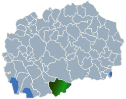
Brnik
Brnik (Bitola - Novaci area)
Brnik / Брник

-
English name:Brnik
-
Macedonian name:Брник
-
GPS Coordinates:Latitude: 41° 4' 55.33" N
Longitude: 21° 38' 27.32" E -
Area phone code:047
-
Postal code:7213
-
Car plates:BT
-
Time zone:
Summer (DST)CET (UTC+01:00)
CEST (UTC+02:00) -
Population:2 - 2002 census
-
Population density:0.06% of total 3,549 in municipality
About Brnik
Brnik is a village in the Novaci municipality of Macedonia. Brnik original name (with diacritics) is Brnik. Brnik distance is 15.79 km / 9.81 mi away from the center of the municipality.
Brnik accommodation: Brnik hotels - Brnik apartments
With Makedonija.name and Booking.com the best price is guaranteed!
Brnik hotels map is available on the target page linked above.
Brnik hotel deals include also long stay accommodation Brnik offers. Take advantage of our exclusive offers and long stay discounts for selected Brnik hotels' suites.
Brnik map
Welcome to the Brnik google satellite map! Brnik Village is situated in Municipality of Novaci, Bitola, Macedonia, its geographical coordinates are 41° 4' 55.33" North, 21° 38' 27.32" East.
Brnik map - Brnik google satellite
[Map Height : Small - Medium - Large]
Photos nearby Brnik - Brnik image gallery
See Brnik photos and images from satellite below, explore the aerial photographs of Brnik in Macedonia.


makedonija.name doesn't own or control these photos.
Photos provided by Panoramio are under the copyright of their owners.
Places nearby Brnik
- Rapesh 2.36 km
- Iveni 4.26 km
- Makovo 4.82 km
- Grunishta 5.6 km
- Grumazi 6.37 km
- Dolno Orehovo 6.95 km
- Zovikj 7.12 km
- Orle 7.72 km
- Budimirci 7.95 km
- Polog 8.54 km
- Paralovo 8.59 km
- Suvodol 8.72 km
- Gnilezh 8.97 km
- Meglenci 9.56 km
- Crnichani 9.7 km
- Mojno 9.77 km
- Armatush 9.8 km
- Chanishte 10 km
- Petalino 10.14 km
- Gradeshnica 10.23 km
- Puturus 11.06 km
- Vranjevci 11.12 km
- Baldovenci 11.38 km
- Lopatica 11.67 km
- Tepavci 11.9 km
- Manastir 11.93 km
- Skochivir 12.14 km
- Musinci 12.67 km
- Novo Selo 13.06 km
- Slivica 13.34 km
- Beshishte 13.42 km
- Biljanik 13.52 km
- Dedebalci 13.56 km
- Alinci 13.77 km
- Gorno Aglarci 13.8 km
- Veleselo 13.91 km
- Krushevica 13.93 km
- Dalbegovci 14.28 km
- Dolno Aglarci 14.38 km
- Podmol 14.62 km
Links
Places in municipality
- Armatus
- Bac
- Baldovenci
- Biljanik
- Brod
- Budimirci
- Dalbegovci
- Dobrodrveni
- Dobromiri
- Dolno Aglarci
- Dolno Orehovo
- Germijan
- Gneotino
- Gnilez
- Gorno Aglarci
- Gradesnica
- Grumazi
- Grunista
- Iveni
- Makovo
- Meglenci
- Novaci
- Novo Selo
- Orle
- Paralovo
- Petalino
- Polog
- Rapes
- Ribarci
- Skocivir
- Slivica
- Sovikj
- Suvodol
- Tepavci
- Veleselo
- Vranjevci
- Zivojno
- Zovikj


