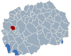
Municipality of Zajas
Municipality of Zajas
Општина Зајас

-
Statistical region:Southwestern
-
GPS Coordinates:41° 36' 3.84" N, 20° 54' 57.27" E
-
Area:161 km2 (100.04 sq mi)
-
Area phone code:045
-
Car plates:OH
-
Inhabited places:13
-
Population:11,605 - 2002 census
-
Population density:72.08 people/km2 (116 people/sq mi)
-
Address:Municipality of Zajas
6253 Zajas, Macedonia -
WWW:www.komunazajazit.gov.mk
Places in Municipality of Zajas
-
Zajas (village) - seat of Municipality of Zajas
-
Villages Zajas municipality (13)
- Bacista
- Bukojcani
- Dlapkin Dol
- Dolno Strogomiste
- Gorno Strogomista
- Gresnica
- Kolari
- Kolibari
- Lesnica
- Midinci
- Recani Zajasko
- Tajmiste
- Zajas
About Municipality of Zajas
Zajas is a municipality in the southwestern part of Republic of Macedonia. Zajas is the name of the village where the municipal seat is found. Zajas municipality is part of Southwestern statistical/administrative region of Macedonia.
The population of the Zajas municipality is 11,605 of whom 4,712 live in the municipality center Zajas, while the rest lives in the villages of the municipality.
Municipality of Zajas map
Welcome to the Zajas municipality google satellite map!
Zajas municipality is situated in Southwestern region of Macedonia, and its central area coordinates are 41° 36’ 3.84” North, 20° 54’ 57.27” East and its original name (with diacritics) is Zajas.
Zajas hotels map is available on the target page linked above.
Municipality of Zajas google satellite map
Photos nearby Municipality of Zajas area
See Municipality of Zajas photos and images from satellite below, explore the aerial photographs of Municipality of Zajas in Macedonia.


