LOCATION
:: LOCATION OF THE REPUBLIC OF MACEDONIA ::...
The Republic of Macedonia is located on the Balkan peninsula in Southeastern Europe. The territory of republic is located between 40 deg 51' and 42 deg 22' north latitude and 20 deg 27'27'' and 23 deg 05', east longitude. It is part of the larger geographic region of Macedonia which includes also Pirin Macedonia in Bulgaria and Aegean Macedonia in Greece. The territory of the republic is sometimes called Vardar Macedonia after the Vardar River, which flows through the country southeast into Greece. The republic is landlocked. It has common boundaries with Albania in the West, Bulgaria in the East, Greece in the South, and Serbia in the North.
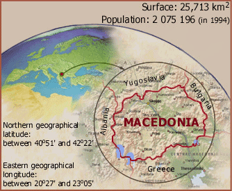
The Republic of Macedonia is situated in southern Europe on the Balkan Peninsula. Occupying a central geographical position in the Balkans, it is also called Heard of the Balkans, there are transportation and communications crossroads linking Europe, Asia and Africa. Lying at the center of the Balkans, Macedonia is at the junction of the main routes which have for millenniums linked the West to the Orient. It covers an area of 25,713 square kilometers and borders with Bulgaria to the east, Greece to the south, Albania to the west and Serbia to the north. Macedonia has 850 kilometers of frontiers with its neighbors. The longest is the border with Greece, 262 km; that with Serbia & Montenegro (FR Yugoslavia) is 232 km in length, that with Albania is 191 km and that with Bulgaria is 165 km.
The borders with the Federal Republic of Yugoslavia, Bulgaria and Albania are predominantly natural, following high mountain ridges. The border with Greece is less natural as it crosses Lake Doran, Lake Prespa and the Patagonia Valley. However, only the border with FR Yugoslavia (Serbia) is simultaneously an ethnic one. The frontiers with the other three neighboring countries are not ethnic, since large and compact groups of ethnic Macedonians live there.
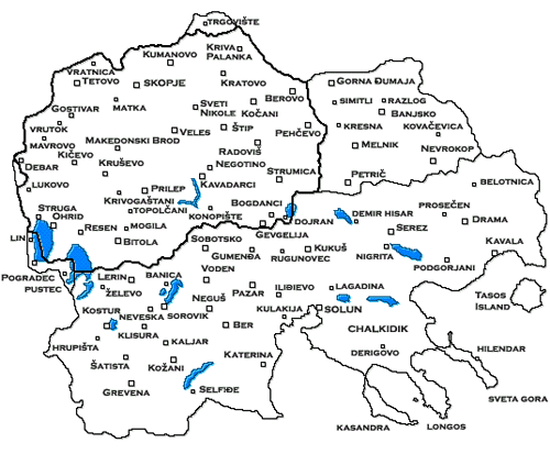
Macedonia's borders are mostly land frontiers (786km); only 48km lie across lakes and 16km along rivers. Until the proclamation of its independence, Macedonia had only seven international border crossing points. There were three with Bulgaria: Deve Bair (Kriva Palanka, MK - Kjustendil, BG), Delčevo (Delčevo, MK - Blagoevgrad (Gorna Đumaja), BG) and Novo Selo (Strumica, MK - Petrič, BG). Three with Greece: Dojran (Star Dojran, MK - Doirani, GR), Bogorodica (Gevgelija, MK - Thessaloniki (Solun), GR) and Međitlija (Bitola, MK - Florina (Lerin), GR).
There was only one border crossing point with Albania: Kjafasan (Struga, MK - Pogradec, AL). The small number of international border crossing points, particularly with Albania, created serious difficulty for the normal circulation of people and goods. In 1992, on the basis of international agreements with Albania, border crossings were opened at the monastery Sveti Naum (Ohrid, MK - Pogradec, AL), Stenje (Resen, MK - Korča, AL) and Blato (Debar, MK - Tirana, AL). Arrangements for the opening of another international border crossing point to Bulgaria, Hlepalo (Berovo), are in their progress.
Six international border crossing points have been set up with the Federal Republic of Yugoslavia: Blace (Skopje, MK - Pristina, YU, Tabanovce (Kumanovo, MK - Vranje, YU), Jažince (Tetovo, MK - Priština, YU), Sopot (on the old way Kumanovo, MK - Bujanovac, YU), Pelince (Kumanovo, MK - St. Prohor Pčinjski, YU) and Volkovo (railway cross point Skopje, MK - Priština, YU).
:: THE ENTIRE REGION MACEDONIA ::...
There are big regions in the Balkan Peninsula. On this region, called Macedonia, (Makedonija-Macedonian; Makedonia-Greek; Makedonya - Bulgarian), borders are on north to Šar Mountain, Skopska Crna Gora, Kozjak, Osogovo and Rila mountains and on west the mountains Korab, Karaorman, Dešat and Jablanica. On South the river Bistrica, and the coast of the Aegean Sea the river Mesta way in, in the Aegean Sea and the mountains Gramos and Pind and on east the river Mesta and the Rhodope mountains. This region covers an area of 68,451 square km, from which only 37,51%, 25.713 square km belongs to the Republic of Macedonia. The other part are occupied by Greece and Bulgaria, since the Balkan Wars (1912-1913). They are known as Aegean Macedonia (Greece), that covers 34,411 sq km and Pirin Macedonia (Bulgaria), that covers 6,798 sq km. And also a small region is given to Albania, the region of Golo Brdo and Mala Prespa (with Pogradec), that covers 802 sq km. In this areas dominant language is Macedonian.
"The Macedonia ethnical-geographical map"
Macedonia's location is excellent. There are important merchant routes passing in the region and also the most important road in the Balkan Peninsula. By the valleys of Vardar and Struma is open to the Aegean Sea. By the valley of Vardar which is connected with the Kumanovo-Presevo water section is connected with the valley of South Morava. The ancient, most important and known road Via Egnatia - Rome (Italy) - Drac (Albania) - Elbasan (Albania) - Ohrid (Macedonia) - Bitola (Macedonia) - Solun (Salonica, Greece) - Constantinople (Istanbul, Turkey).
